Embarking on a boat journey is always thrilling, offering endless possibilities and new experiences. But even for those who’ve been sailing for years or are just starting, finding your way on the water can be tricky.
Luckily, technology has come to the rescue with boating navigation apps. In this beginner’s guide, we’ll explore these apps, what they can do, and how they make boating more accessible for everyone.
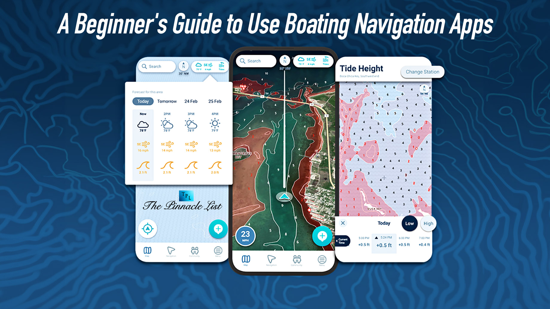
Understanding Boating Navigation Apps
Boating navigation apps are digital tools designed to assist boaters in navigating the water safely and efficiently. These apps utilize GPS technology and nautical charts to provide real-time information about your location, route planning, weather conditions, and points of interest along your journey.
Key Features of Boating Navigation Apps
GPS Tracking
Boating navigation apps use GPS technology to pinpoint your exact location on the water. This feature allows you to track your progress, navigate unfamiliar waters, and avoid hazards such as shallow areas or submerged obstacles.
Nautical Charts
Boating navigation apps are equipped with detailed nautical charts that display important information such as water depths, navigational aids, marinas, and anchorages. These charts help you plan your route effectively and stay on course while avoiding potential obstacles.
Route Planning
Boating navigation apps make route planning easy. Simply input your desired destination, and the app will calculate the best route for you, taking into account factors such as distance, water depth, and navigational hazards. You can also customize your route by adding waypoints or adjusting your course as needed.
Weather Forecasts
Staying informed about weather conditions is essential for safe boating. Many boating navigation apps provide real-time weather forecasts, including wind speed and direction, wave height, and precipitation. This information helps you make informed decisions about when to set sail and how to adjust your route to avoid inclement weather.
AIS Integration
Automatic Identification System (AIS) integration is a valuable feature found in some boating navigation apps. AIS allows you to see real-time information about nearby vessels, including their position, speed, and heading. It helps you maintain situational awareness and avoid collisions while on the water.
Choosing the Right Boating Navigation App
With so many boating navigation apps available, choosing the right one for your needs can be overwhelming. Here are some factors to consider when selecting a boating navigation app:
- User Interface: Look for an app with an intuitive and easy-to-use interface. The app should be user-friendly, with clear navigation menus and customizable settings.
- Chart Coverage: Ensure that the app provides comprehensive chart coverage for the areas where you’ll be boating. Some apps offer charts for specific regions or countries, so be sure to choose one that covers your intended cruising grounds.
- Offline Access: Consider whether the app allows for offline access to charts and navigation data. It is essential when boating in remote areas with limited or no cellular coverage.
- Compatibility: Check the compatibility of the app with your device’s operating system (iOS or Android) and any additional hardware you may be using, such as chart plotters or AIS receivers.
- Reviews and Ratings: Read reviews and ratings from other boaters to gauge the app’s reliability, accuracy, and customer support. Look for apps with positive feedback and a strong track record of performance.
Putting Your Boating Navigation App to Use
Once you’ve chosen the right boating navigation app for your needs, it’s time to put it to use on the water. Here are some tips for making the most of your boating navigation app:
Familiarize Yourself
Before setting sail, familiarize yourself with the app’s features and settings. Practice using the app in different scenarios to build confidence in its capabilities.
Plan Your Routes
Use the app to plan your routes, taking into account factors such as weather conditions, tidal currents, and navigational hazards. Consider creating waypoints along your route to help guide your journey.
Stay Updated
Keep your boating navigation app updated with the latest charts, software updates, and weather forecasts. Check for updates regularly to ensure that you have access to the most accurate and up-to-date information while on the water.
Backup Navigation
While boating navigation apps are valuable tools, it’s always wise to have backup navigation methods on board, such as paper charts, a compass, and a VHF radio. These backups can provide essential navigation assistance in the event of a technology failure or loss of signal.
Practice Safe Boating
Remember that boating navigation apps are aids to navigation and should not replace basic seamanship skills and good judgment. Always practice safe boating practices, including wearing a life jacket, maintaining a proper lookout, and obeying maritime rules and regulations.
Conclusion
Boating navigation apps are powerful tools that can enhance your boating experience and help you navigate the water safely and efficiently.
By understanding the critical features of boating navigation apps, choosing the right app for your needs, and using it effectively on the water, you can enjoy peace of mind, knowing that you have the tools and information you need to navigate with confidence.
So, whether you’re planning a leisurely cruise or embarking on a nautical adventure, consider adding a boating navigation app to your onboard toolkit and set sail with confidence on your next boating excursion.